It’s important to understand what El Niño actually is - and why it matters.
El Niño is a natural climate pattern that occurs when ocean waters in the central and eastern Pacific become unusually warm. That warmth shifts where heat and moisture rise into the atmosphere, which in turn alters global weather patterns - including across the U.S. - by changing storm tracks, temperature patterns, and rainfall distribution.
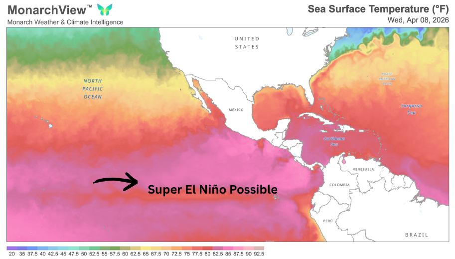
This year, we are closely watching for the development of a potentially strong - possibly even ‘super’ - El Niño. While not an official classification, the term ‘Super El Niño’ is commonly used to describe an exceptionally strong event, typically defined by sea surface temperatures in the tropical Pacific rising at least 2°C (3.6°F) above average - significantly increasing the likelihood of more pronounced, widespread, and longer-lasting impacts across the U.S.
Current outlooks suggest this climate pattern could emerge as early as summer, strengthen through the fall, and reach peak intensity during the winter months, when its influence on U.S. weather is typically most pronounced.
While it’s often associated with fewer Atlantic hurricanes, El Niño also tends to shift storm tracks, increase rainfall in some regions, and amplify heat and dryness in others. These competing signals can lead to highly variable conditions from one region to another.
The Misleading Narrative: “Quiet Hurricane Season”
Early forecasts suggest Atlantic hurricane activity may trend below average, with some guidance indicating the quietest season since 2019.
But focusing only on storm counts creates a false sense of security.
“Similar strong El Niño years have still produced major hurricane landfalls. Take Hurricane Bob (1991) or Hurricane Idalia (2023)- each a reminder that a single storm can define an entire season. Lower frequency does not necessarily mean lower impact.”— Crystal Egger, President, Monarch Weather

1. A Top-Tier El Niño Event
Current forecasts suggest this could rank among the strongest El Niño events on record.
Stronger events tend to amplify downstream impacts, increasing volatility across multiple regions at once.
2. Risk Shifts to the Pacific
As Atlantic activity decreases, the Pacific becomes more active.
This is a classic risk transfer - not a reduction.
3. Heat Becomes a Primary Disruptor
In strong El Niño years, the most intense and persistent heatwaves often shift northward, while the southern U.S. tends to see more cloud cover and fewer prolonged heat extremes. Areas to watch include:
These events impact more than comfort—they drive:
4. Wildfire Risk Shifts
A Super El Niño shifts wildfire risk rather than eliminating it. Wetter periods can temporarily reduce fire danger, but they also promote vegetation growth that later dries out and becomes fuel. As conditions turn hotter and drier, especially in late summer and fall, this can increase the risk of larger, more intense wildfires.
The western U.S. is already heading into an elevated wildfire season, driven by persistent heat, below-normal snowpack, and increasingly dry fuels across much of the region.
5. A Warmer Atmosphere Drives More Volatility
This event is expected to rival - or exceed - the last major El Niño, which contributed to record global temperatures in 2023 and 2024.
A warmer atmosphere holds more moisture and energy, increasing the likelihood of:
6. Flash Flooding Will Be a Defining Risk
One of the most often underestimated El Niño impacts is widespread flash flooding.

While hurricanes may be fewer, flooding events become:
Areas to watch closely:
These events are often the most disruptive from an operations and restoration standpoint.
What This Means for Business
A Super El Niño shifts the risk for businesses to persistent, multi-region disturbances. For risk managers and response teams, this translates to higher demand from multiple smaller events, simultaneous deployments in different areas, and a greater need for real-time situational awareness.
WORK WITH MONARCH:
Our dynamic interactive weather platform, precisely crafted by our team of expert meteorologists and GIS analysts. MonarchView™ filters out unnecessary information, providing the actionable insights you need to optimize daily operations with confidence and ease. Message us directly to set up a demo and complimentary consultation: Team@MonarchWeather.com.
About Monarch Weather & Climate Intelligence
Monarch challenges leaders to discover a new way to forecast their business. Keep Monarch on your Radar.
We are a woman-owned business with a team of Certified Consulting Meteorologists (CCM) and GIS Analysts, providing meteorological and climate services via custom forecasting, modeling and advisory within the insurance, tech, energy, real estate, transportation and agricultural sectors.